QgisUser0004 - Military Maps HD
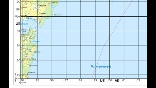
Military maps (ground) have very specific ways to present UTM coordinates, and they support the MGRS reporting system. In the video I use two python files: Alexandre Neto: https://gisunchained.wordpress.com/2014/09/09/coordenadas-dos-cantos-do-mapa-em-qgis-map-corner-coordinates-in-qgis/ (https://www.dropbox.com/s/b0ejc7216eboach/user_functions.zip?dl=0) Any My own: https://github.com/klakar/QGIS_resources/blob/master/collections/Geosupportsystem/python/expressions/layoutfunctions.py Note the limitations: - Only supports UTM grids! - Only works completely inside ONE UTM zone. - MGRS functions only adapted for Northern Hemisphere (for now).
 HD
HD
 HD
HD HD
HD HD
HD HD
HD HD
HD HD
HD HD
HD HD
HD HD
HD HD
HD HD
HD HD
HD HD
HD HD
HD HD
HD HD
HD HD
HD HD
HD HD
HD HD
HD HD
HD HD
HD HD
HD HD
HD HD
HD HD
HD HD
HD HD
HD HD
HD HD
HD