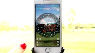
Spyglass – how to measure the size of objects and the distance to them (iPhone, iPad, iOS) HD
Spyglass is a powerful outdoor and off-road navigation toolkit for those who trek around wilderness and need a reliable backup. Download on the App Store: https://itunes.apple.com/us/app/spyglass/id332639548?mt=8 This video shows how using the Sextant tool you can measure the size of a building/object if you know the distance to it. Or vice versa – how you can measure the distance if you know the size. *** WHAT IS SPYGLASS? Spyglass is an all-in-one navigation toolkit for those who trek around wilderness and need much more muscle than regular maps and standard navigators. Designed primarily for outdoor and off-road navigation, it serves as high-tech viewfinder (HUD), milspec compass with maps, gyrocompass, tactical GPS, waypoint tracker, speedometer, altimeter, Sun, Moon and star finder, gyro horizon, rangefinder, variometer, coordinate converter, sextant, inclinometer, angular calculator and camera. WHO IS IT FOR? Among Spyglass users are: hunters, sailors, off-roaders, hikers, geocachers, bikers, land surveyors, engineers, pilots, marines, astronomers, S&R workers, SWAT snipers, army soldiers, firemen, policemen, real estate agents, photographers, software architects, etc. WHAT CAN IT DO? Spyglass uses camera as a viewfinder and overlays a myriad of positional information using every sensor available on your device. Save your custom places and waypoints, see them on maps or augmented reality display and navigate precisely to them later. Navigate by the sun, moon and stars, measure size of objects, snap pictures with all the data overlaid and employ one of a dozen different coordinate systems, ranging from civilian to military. Here’s the list of the most widespread uses among Spyglass owners: • mark hunting and fishing spots and navigate to them later • hike/drive in off the beaten path and stay on course • find your way out of swamps, thick jungles and secluded mangrove bayous • see where you are and which way you are pointing • find your boat launch or way to the harbor at night/in the fog • as a backup to main nav systems on a boat/plane/in a car • mark places where you find things and document them with pictures • check altitude on hikes • find where you’ve left your car in the woods or in a parking lot • get accurate vehicle speed • point satellite dishes • estimate heights of structures • calculate distance and angles • convert coordinates • control vertical speed when flying • document the places you have visited to get back to them later • find your way when in strange cities or if you have no sense of direction • align your telescope drive • for geocaching, esp. for puzzle caches that lead you through multiple jumps to a target • document significant locations on the property for future/historical reference • check property boundaries and room directions • tell which directions fences and roads are running • take photos of trail hazards/violations/incidents, overlaid with the location data (latitude and longitude, etc.) • for
Похожие видео
 HD
HD HD
HD
 HD
HD HD
HD HD
HD HD
HD HD
HD HD
HD HD
HD HD
HD
 HD
HD HD
HD HD
HD HD
HD HD
HD HD
HD HD
HD HD
HD HD
HD HD
HD
 HD
HD HD
HD HD
HD HD
HD HD
HD
 HD
HD HD
HD
Показать еще