LWJGL Terrain Heightmap Test
Working realistic looking terrain! The program uses GL_TRIANGLE_STRIPs to create a flat mesh. Then it uses data from a heightmap, in this case an image file, to determine the height of each vertex. This test shows a mountain range that I drew in paint.NET. Next step: textures and collision! Heightmap: http://imageshack.us/photo/my-images/848/testoy.png/


 HD
HD HD
HD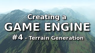 HD
HD
 HD
HD HD
HD HD
HD HD
HD HD
HD HD
HD HD
HD HD
HD HD
HD HD
HD HD
HD HD
HD HD
HD HD
HD HD
HD HD
HD HD
HD HD
HD HD
HD HD
HD HD
HD HD
HD HD
HD HD
HD HD
HD![Land Rover Discovery (2018) Off-Road Test [YOUCAR]](data:image/gif;base64,R0lGODlhAQABAIAAAAAAAP///yH5BAEAAAAALAAAAAABAAEAAAIBRAA7)